Dear all,
we have recently created a new dataset in the Eurac STAC catalogue.
For example, see https://stac.eurac.edu/collections/MOD10A1v61/items/20230120000000 for a specific image.
When trying to access it though a very basic script and download it:
import openeo

conn = openeo.connect("https://openeo.dataspace.copernicus.eu/").authenticate_oidc()

modis = conn.load_stac("https://stac.eurac.edu/collections/MOD10A1v61",
                      temporal_extent = ["2023-01-20","2023-01-21"])

modis.download("sample_modis.tiff")
the tif file presents a wrong spatial extent w.r.t. the original data loaded in the STAC catalogue as well as the bbox that is specified in the STAC, i.e.,
631800,5167700, 655800,5184200
while the downloaded output presents this extent 631000,5167000,656500,5185000.
Thanks in advance for your help,
Valentina
Hi Valentina,
This is a known issue: load_stac: pixel shift · Issue #648 · Open-EO/openeo-geopyspark-driver · GitHub
It is only planned to be fixed mid May tough. Would that work out for you?
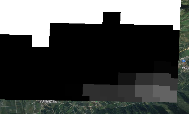
When overlaying sample_modis.tiff with
https://eurac-eo.s3-eu-west-1.amazonaws.com/MOD10A1v61/SENALES/SCF_20230120000000.tif
the difference is clearly visible
1 Like
@emile.sonneveld @jeroen.dries any update on this issue?
Thanks,
Valentina
It’s still very much on the agenda to be fixed in the near future, but got pushed back by a bunch of other urgent issues.
Hey @valentina.premier
To pixel align the output, we will need the step size of the data.
Typically it is specified like “cube:dimensions”… “step”: 500.
Would it be possible to add that to this collection? https://stac.eurac.edu/collections/MOD10A1v61
In the meantime, we can adapt openEO to read this property
Hey @emile.sonneveld
thanks for your answer! We have just updated the STAC collection
Hey, that looks fine.
I am working on reading the metadata correctly now.
1 Like
Hey,
A fix for this pixel shift is now on CDSE staging:
https://openeo.dataspace.copernicus.eu
Emile Sonneveld
1 Like
The fix is now also in CDSE production: https://openeo.dataspace.copernicus.eu
2 Likes