Hi!
I would like to know if there is a way to import a geojson polygon when defining the spatial extent of processes in visual mode.
Thanks
Hi!
I would like to know if there is a way to import a geojson polygon when defining the spatial extent of processes in visual mode.
Thanks
Hey,
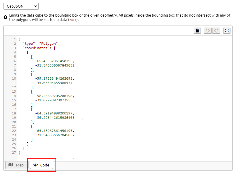
not yet, but I just implemented this functionality for you. It should be available after the next deploy on Monday. You can then select the “Code” mode and either copy&paste or drag&drop GeoJSON directly:
Hope it helps and let me know if you find any issues with it.
Best,
Matthias
Thanks!
I’ll let you know
Elia.
The Editor just got redeployed.
Make sure to reload the page. The version number should be 0.11.0-rc.1, otherwise you need to delete the cache files in the Browser once.
The new version also includes some other changes so don’t be confused if the Map on the right is missing etc.
Dear Matthias,
I have just included the coordinates (simplifyied) of my geojson,
but the result is the enveloping rectangle of the polygon when I export the result to tif.
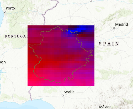
Even worse is when I export the result to netCDF, which does not take the southeast boundary and returns a much larger raster of the enveloping polygon.
I am working with the new version 0.11.0-rc.1. Maybe I’m doing something else wrong
Thanks
I’m sorry about that. This doesn’t look like an issue with the Web Editor itself, but seems to be an issue with the data processing / back-end. @jeroen.dries Could you have a look at that? @equiros Could you post some more details like the job IDs so that we can check the internals, please?
Hi Elia,
it depends on the actual processes that you are using. Do you have a more complete view of the process graph?
Basically, I believe you want to use mask_polygon or filter_spatial to get rid of the pixels outside of the polygon.
The netCDF export currently indeed does not yet fully crop the output, we’ve realized that this seems surprising, so I plan to try and change this.
@jeroen.dries With regards to the mentioned processes: shouldn’t that be included directly in load_collection without calling any of the other two processes?
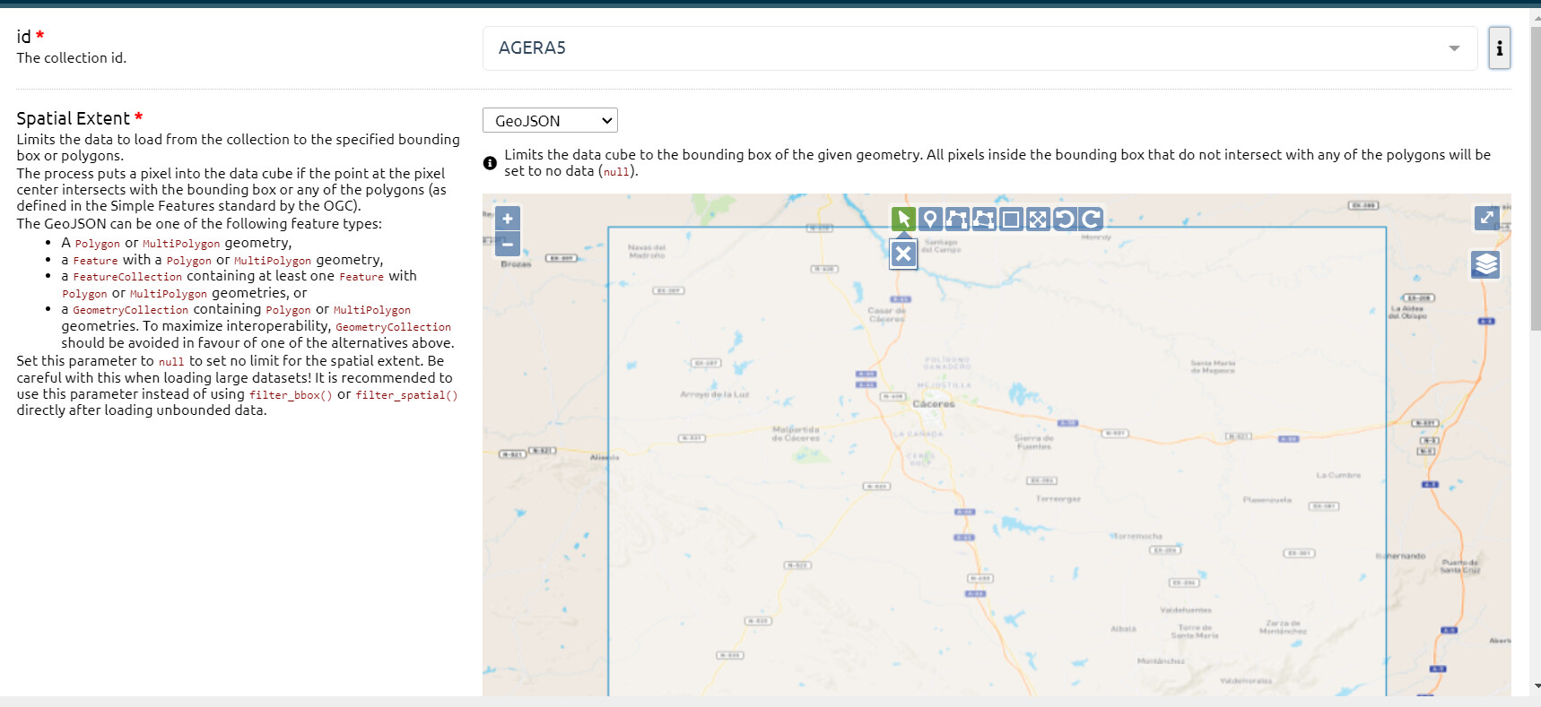
For GeoJSON input in load_collection it says:
Limits the data cube to the bounding box of the given geometry. All pixels inside the bounding box that do not intersect with any of the polygons will be set to no data (
null).
Dear Jeroen,
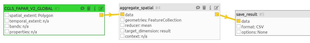
As I could not have all the data (netCDF and tiff) with the same dimensions, we decided to use a geojson grid point to extract values in all datacubes that we need. we are using the “agregate_spatial” proccess to do that.
We are now just trying to do it, but we are having problems with coordinate systems and we don’t quite understand why. In some of the data collections the coordinate system of the data does not appear and we do not know in which system we have to introduce the geojson.
Thanks.
Hi,
if using geojson, and as a general default, it’s best to use EPSG:4326 so regular lat/lon coördinates.
If you still have problems, can you point me to the specific error?
thanks,
Jeroen
Hi!
It works with this EPSG!
But… another problem:
Whenever we try to add a temporal extent (of past years), we obtain an error saying:
Failed to process synchronously on backend vito: OpenEoApiError(’[400] unknown: no fitting raster sources found’)
ERROR
Code: Internal
ID: fb2d531d-ae3c-489a-ae34-9b2cec6f5fdc
It is not the first time that we have this error with other collections.
Thanks!
Hello!
Do you know what is the problem?
I also have a question regarding the initial time of temporal series: although in the description of some of the data series it is stated that data are available from 1999, when I download the data, they start from much later years, for example from 2015 in the case of the meteorological data.
Do you know why this might be?
Thanks!
Hi,
sorry, for the slow reply. Yes, it sounds like the data is not available for that time period over the AOI provided. It looks like it starts in 2014, not in 1999 as provided by the metadata. Which temporal extent are you requesting?
@jeroen.dries I can’t find the collection in the Terrascope Viewer. Can you confirm which temporal extent is available?
Best,
Matthias
I need data from 2005-2006.
Thanks!
I believe I found the issue. I’ll need to implement a fix for this to make it also work with data recorded by spot vgt. (The collection is somewhat heterogenous in naming conventions, causing this.)
I’ll log an issue and let you know when it’s fixed.
Can you try again using openeo-dev.vito.be?
@equiros To clarify, @jeroen.dries is asking you to connect to a development version of the back-end. As you are using the openEO Plaform Editor at editor.openeo.cloud, you need to switch to https://editor.openeo.org and input there as the server the openeo-dev.vito.be URL and then you can mostly connect as before with EGI check-in. The Editor then looks basically the same, just with a bit different styling.
Yes!! it works now!! I did not put any temporal filter and now I have data from 1999, as the metadata says.
Thank you both very much!!!
Good morning!
Unfortunately, the problem still persits with some collections, such as CGLS_LAI_V2_GLOBAL and CGLS_SSM_V1_GLOBAL
Best.
indeed, I was a bit careful in rolling it out so only applied the potential solution to that one layer. Will try to update the others as well.